 Sentinel Alcohol Detox
Key Numbers
- Listed treatment facilities
- 286closed listings excluded
- Facilities per 100,000 residents
- 8.742020 Census population
- Treatment deserts
- 3of 29 counties have no listed facility
- Residents of treatment deserts
- 14,668people in zero-facility counties
- Accept Medicaid
- 81.5%233 of 286 listed facilities
- Population
- 3,271,6162020 Census
Last updated , when the source report was generated.
These figures count listed facilities, not capacity or quality: a listing does not show how many people a facility can treat, how soon, or how well.
How the State Compares

Treatment Deserts
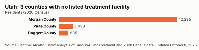
3 counties have no listed treatment facility. Distances are straight-line miles to the nearest listed facility.
| County | Population | Nearest listed facility (miles) |
|---|---|---|
| Morgan County | 12,295 | 19.6 |
| Piute County | 1,438 | 24.9 |
| Daggett County | 935 | 30.6 |
Desert Counties by Population
All Counties, Ranked
| Rank | County | Population | Listed facilities | Per 100,000 | Status |
|---|---|---|---|---|---|
| 1 | Wayne County | 2,486 | 1 | 40.23 | |
| 2 | Rich County | 2,510 | 1 | 39.84 | |
| 3 | Carbon County | 20,412 | 7 | 34.29 | |
| 4 | Emery County | 9,825 | 3 | 30.53 | |
| 5 | Beaver County | 7,072 | 2 | 28.28 | |
| 6 | Grand County | 9,669 | 2 | 20.68 | |
| 7 | Garfield County | 5,083 | 1 | 19.67 | |
| 8 | Millard County | 12,975 | 2 | 15.41 | |
| 9 | Kane County | 7,667 | 1 | 13.04 | |
| 10 | Box Elder County | 57,666 | 7 | 12.14 | |
| 11 | Wasatch County | 34,788 | 4 | 11.50 | |
| 12 | Duchesne County | 19,596 | 2 | 10.21 | |
| 13 | Salt Lake County | 1,185,238 | 118 | 9.96 | |
| 14 | Summit County | 42,357 | 4 | 9.44 | |
| 15 | Sevier County | 21,522 | 2 | 9.29 | |
| 16 | Utah County | 659,399 | 58 | 8.80 | |
| 17 | Juab County | 11,786 | 1 | 8.48 | |
| 18 | Washington County | 180,279 | 15 | 8.32 | |
| 19 | Sanpete County | 28,437 | 2 | 7.03 | |
| 20 | San Juan County | 14,518 | 1 | 6.89 | |
| 21 | Tooele County | 72,698 | 5 | 6.88 | |
| 22 | Weber County | 262,223 | 17 | 6.48 | |
| 23 | Cache County | 133,154 | 8 | 6.01 | |
| 24 | Iron County | 57,289 | 3 | 5.24 | |
| 25 | Davis County | 362,679 | 18 | 4.96 | |
| 26 | Uintah County | 35,620 | 1 | 2.81 | |
| 27 | Daggett County | 935 | 0 | 0.00 | Treatment desert |
| 28 | Morgan County | 12,295 | 0 | 0.00 | Treatment desert |
| 29 | Piute County | 1,438 | 0 | 0.00 | Treatment desert |
Methodology
Every number on this page is calculated directly from public records; no figure is estimated or written by hand.
Facilities are the treatment locations listed in SAMHSA's FindTreatment.gov locator, each counted once by its listing ID. Closed listings are excluded; active and unconfirmed listings are included (unique IDs; closed excluded; active and unconfirmed included).
Density divides the number of listed facilities by the 2020 Census resident population and multiplies by 100,000.
A treatment desert is a county with zero listed facilities. Facilities are placed in counties by their coordinates against Census county boundaries; deserts are only reported when every listed facility in the state has a verified county.
The Medicaid share is the number of listed facilities that report accepting Medicaid divided by all listed facilities; facilities that do not report it count as not confirmed.
Distances are straight-line (great-circle) miles from a county's Census reference point to the nearest geocoded listed facility in any state. They are not driving distances.
These are listed facilities, not capacity or quality: counts describe listings, not beds, wait times, outcomes or proof of access to care.
Known Gaps in This Data
- None reported for this state.
Sources and Reuse
- SAMHSA FindTreatment.gov treatment locator (Substance Abuse and Mental Health Services Administration): Listed treatment facilities, operating status and Medicaid acceptance.
- 2020 Census redistricting data (P.L. 94-171), table P1 (U.S. Census Bureau): State and county resident population (2020).
- 2020 cartographic boundary files, counties (1:500,000) (U.S. Census Bureau): County boundaries for assigning facilities to counties and for the county map.
- 2020 Census Gazetteer files, counties (U.S. Census Bureau): County reference points for nearest-facility distances.
Download this data: County table (CSV) · Full data (JSON)
Licence: this data and its charts are published under the Creative Commons Attribution 4.0 (CC BY 4.0) licence. You may copy, share and adapt them, including commercially. Attribution: credit Sentinel Alcohol Detox and link to the source page, https://sentinelalcoholdetox.com/data/utah/.